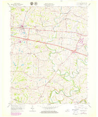
1960 Map of Simpsonville
USGS Topo · Published 1979About this map
Simpsonville and Finchville anchor this Shelby County landscape, which shows a transition from traditional rail-line commerce to modern highway infrastructure by the late 1970s. The northern corridor is defined by the Louisville and Nashville railroad, passing through Scotts Station, while the Southern line cuts across the center through Veechdale. Local history is preserved in the location of the Buck Creek Sch and Shiloh Ch, alongside numerous family-named rural routes like Blaydes Lane and Parent Lane. The area's hydrology is dominated by the winding path of Bullskin Creek and Brashears Creek, the latter featuring Picketts Dam. Notable institutions such as Lincoln Ridge are mapped alongside small rural settlements like Montclair and Joyes, providing a detailed look at the post-war development of this central Kentucky region before more recent suburban growth altered these agricultural patterns.
Find a feature on this map
36 named features on this map. Tap any name to fly to it.
Don’t see what you’re looking for? This feature index may not catch every label — zoom into the map to look around manually.
Map Details
Editions of this 1960 Simpsonville Map
3 editions found
Other maps of this area

1923 · Waddy
USGS Topo · 1:48,000

1925 · Mount Eden
USGS Topo · 1:48,000

1927 · Mount Eden
USGS Topo · 1:62,500

1928 · New Castle
USGS Topo · 1:48,000

1929 · Taylorsville
USGS Topo · 1:62,500

1932 · New Castle
USGS Topo · 1:62,500

1932 · La Grange
USGS Topo · 1:62,500

1951 · Crestwood
USGS Topo · 1:24,000

1951 · Fisherville
USGS Topo · 1:24,000

1951 · Waterford
USGS Topo · 1:24,000