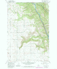
1967 Map of Sixmile Creek
USGS Topo · Published 1985About this map
The Clearwater River cuts a deep path through this North Central Idaho landscape, forming the natural boundary between Lewis and Idaho counties. This 1967 survey, with updates from the 1980s, highlights a rugged terrain defined by significant drainage systems including Lolo Creek, Fivemile Creek, and Sixmile Creek. The eastern bank of the river is traced by a major roadway, while the interior uplands are accessible primarily via a Jeep Trail. Evidence of local infrastructure and resource extraction appears in the southwest with a Substation and scattered industrial sites like a Gravel Pit and several Borrow Pits. The map captures the area before significant modern development, showing the tributary of Effie Creek and the dense contouring that characterizes this river canyon region.
Find a feature on this map
11 named features on this map. Tap any name to fly to it.
Don’t see what you’re looking for? This feature index may not catch every label — zoom into the map to look around manually.
Map Details
Editions of this 1967 Sixmile Creek Map
3 editions found
Other maps of this area

1924 · Kamiah
USGS Topo · 1:125,000

1955 · Pullman
USGS Topo · 1:250,000

1958 · Pullman
USGS Topo · 1:250,000

1967 · Mohler
USGS Topo · 1:24,000
1967 · Kamiah
USGS Topo · 1:24,000

1967 · Sixmile Creek
USGS Topo · 1:24,000

1967 · Rudo
USGS Topo · 1:24,000

1967 · Cottonwood NE
USGS Topo · 1:24,000

1967 · Orofino West
USGS Topo · 1:24,000
1967 · Nezperce
USGS Topo · 1:24,000