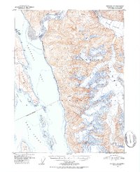
1951 Map of Skagway A-1
USGS Topo · Published 1952About this map
The Tongass National Forest dominates this coastal landscape where massive glacial ice meets the deep waters of the Pacific. The Meade Glacier carves through the northeastern mountains, feeding the braided channels of the Katzehin River as it empties into the Chilkoot Inlet. This 1951 survey documents the intricate marine geography of the region, from the narrow Chilkat Peninsula separating the two primary inlets to the chain of smaller landmasses like Anyaka Island and Shikosi Island in the Lynn Canal. Inland, the terrain rises sharply to Sinclair Mtn, illustrating the steep vertical relief characteristic of the Southeast Alaskan wilderness. The map provides a detailed view of the coastline just south of Skagway before later development, showing natural landmarks like Battery Point and Kelgaya Point in their mid-century state.
Find a feature on this map
21 named features on this map. Tap any name to fly to it.
Don’t see what you’re looking for? This feature index may not catch every label — zoom into the map to look around manually.
Map Details
Editions of this 1951 Skagway A-1 Map
2 editions found
Other maps of this area

1948 · Juneau D-3
USGS Topo · 1:63,360

1948 · Skagway A-1
USGS Topo · 1:63,360

1949 · Atlin
USGS Topo · 1:250,000

1949 · Juneau D-5
USGS Topo · 1:63,360

1949 · Skagway B-1
USGS Topo · 1:63,360

1949 · Juneau D-4
USGS Topo · 1:63,360

1949 · Juneau D-3
USGS Topo · 1:63,360

1951 · Juneau
USGS Topo · 1:250,000

1951 · Skagway A-1
USGS Topo · 1:63,360

1951 · Atlin
USGS Topo · 1:250,000