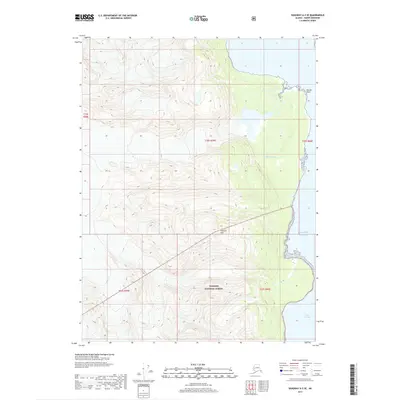
2017 Map of Skagway A-2 SE
USGS Topo · Published 2017About this map
Tongass National Forest dominates this coastal Alaskan landscape, where the high peaks of the coastal range meet the waters of the Gulf of Alaska. The map centers on the dramatic geography surrounding Glacier Point, a prominent coastal feature where the Glacier River meets the tidal flats. To the south, Sullivan Mtn rises as a significant landmark above the forested terrain. This survey illustrates the intricate relationship between the mountainous interior and the intricate waterways of the Lynn Canal. The mapping detail reflects the complex glacial and fluvial processes that define the Haines Borough coastline, capturing the precise boundaries of the National Forest and the transition from alpine summits to maritime environments.
Find a feature on this map
11 named features on this map. Tap any name to fly to it.
Don’t see what you’re looking for? This feature index may not catch every label — zoom into the map to look around manually.
Map Details
Editions of this 2017 Skagway A-2 SE Map
This is the sole edition of this map. No revisions or reprints were ever made.
Other maps of this area

1948 · Skagway A-1
USGS Topo · 1:63,360

1949 · Juneau D-5
USGS Topo · 1:63,360

1951 · Juneau
USGS Topo · 1:250,000

1951 · Skagway A-1
USGS Topo · 1:63,360

1952 · Skagway
USGS Topo · 1:250,000

1954 · Skagway A-2
USGS Topo · 1:63,360

1961 · Skagway
USGS Topo · 1:250,000

1962 · Juneau
USGS Topo · 1:250,000
1991 · Skagway A-1 NW
USGS Topo · 1:25,000
1991 · Skagway A-2 NE
USGS Topo · 1:25,000