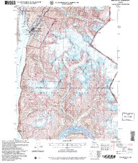
2004 Map of Skagway B-1
USGS Topo · Published 2007About this map
Skagway and its surrounding wilderness are captured here during a period of modern preservation and historical reflection. The landscape is dominated by the Tongass National Forest and the Klondike Gold Rush National Historical Park, areas that protect the legacy of the late 19th-century stampede. The iconic White Pass and Yukon Route railway mirrors the path of the Skagway River, while the Klondike Hwy provides northern access. Significant maritime features include the Ferry Terminal Seaplane Base Light and the Low Point Lighthouse Reserve along the deep waters of Taiya Inlet. Local landmarks such as the Gold Rush Cem and the settlement of Liarsville provide direct links to the region's mining heritage. To the east, the dramatic peaks of the Coast Mountains and the Sawtooth Range rise toward the United States and Canada border.
Find a feature on this map
59 named features on this map. Tap any name to fly to it.
Don’t see what you’re looking for? This feature index may not catch every label — zoom into the map to look around manually.
Map Details
Editions of this 2004 Skagway B-1 Map
This is the sole edition of this map. No revisions or reprints were ever made.
Other maps of this area

1948 · Skagway C-2
USGS Topo · 1:63,360

1948 · Skagway A-1
USGS Topo · 1:63,360

1948 · Skagway C-1
USGS Topo · 1:63,360

1949 · Atlin
USGS Topo · 1:250,000

1949 · Skagway B-1
USGS Topo · 1:63,360

1951 · Skagway A-1
USGS Topo · 1:63,360

1951 · Skagway C-1
USGS Topo · 1:63,360

1951 · Atlin
USGS Topo · 1:250,000

1951 · Skagway B-1
USGS Topo · 1:63,360

1951 · Skagway C-2
USGS Topo · 1:63,360