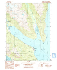
1991 Map of Skagway B-2 SE
USGS Topo · Published 1991About this map
Lutak Inlet and the convergence of several major waterways dominate this coastal landscape, illustrating the strategic and maritime importance of the area near the northern end of the Lynn Canal. The map documents the industrial and military infrastructure of the early 1990s, featuring the Haines Fuel Terminal (US Army) near Tanani Point and a Ferry Dock providing essential transport links. The terrain rises sharply from the tidal flats of Taiyasanka Harbor and Tanani Bay toward the Takshanuk Mountains, where Mount Ripinski stands as a prominent landmark. Settlement is concentrated along the shorelines, with the community of Tanani and the lakeside location of Chilkoot situated near the Chilkoot Lake outflows. The presence of the Haines State Forest and the Lutak Resource Management Area indicates a landscape balanced between natural resource management and critical transportation corridors like the Haines Highway.
Find a feature on this map
31 named features on this map. Tap any name to fly to it.
Don’t see what you’re looking for? This feature index may not catch every label — zoom into the map to look around manually.
Map Details
Editions of this 1991 Skagway B-2 SE Map
This is the sole edition of this map. No revisions or reprints were ever made.
Other maps of this area

1948 · Skagway A-1
USGS Topo · 1:63,360

1949 · Skagway B-1
USGS Topo · 1:63,360

1951 · Skagway A-1
USGS Topo · 1:63,360

1951 · Skagway B-1
USGS Topo · 1:63,360

1952 · Skagway
USGS Topo · 1:250,000

1954 · Skagway B-2
USGS Topo · 1:63,360

1954 · Skagway A-2
USGS Topo · 1:63,360

1961 · Skagway
USGS Topo · 1:250,000
1991 · Skagway B-2 SW
USGS Topo · 1:25,000
1991 · Skagway A-1 NW
USGS Topo · 1:25,000