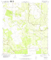
1979 Map of Skidmore NE
USGS Topo · Published 1979About this map
Blanco Creek and Medio Creek meander through this South Texas landscape on the border of Bee and Goliad counties. During the late 1970s, the area was characterized by sparse settlement and a network of watercourses, including Mucorrera Creek, Murphy Creek, and Neddy Creek. The presence of the Mucorrera Cemetery and another smaller Cem suggest early family ranching and community roots in the territory. Industrial activity is represented by several instances of a Gravel Pit and a prominent Pipeline corridor that cuts diagonally across the terrain. Topographical features like Parker Hollow provide variety to the landscape, which is otherwise defined by flowing wells and the drainage basins of the local creek systems.
Find a feature on this map
15 named features on this map. Tap any name to fly to it.
Don’t see what you’re looking for? This feature index may not catch every label — zoom into the map to look around manually.
Map Details
Editions of this 1979 Skidmore NE Map
This is the sole edition of this map. No revisions or reprints were ever made.
Other maps of this area

1953 · Beeville
USGS Topo · 1:250,000

1954 · Skidmore
USGS Topo · 1:62,500

1954 · Refugio
USGS Topo · 1:62,500

1956 · Beeville
USGS Topo · 1:250,000

1960 · Beeville
USGS Topo · 1:250,000

1962 · Melo
USGS Topo · 1:24,000

1963 · Lazy F Ranch
USGS Topo · 1:24,000

1963 · Berclair
USGS Topo · 1:24,000

1978 · Refugio SW
USGS Topo · 1:24,000

1979 · Burkes Ridge
USGS Topo · 1:24,000