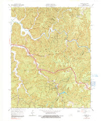
1966 Map of Slade
USGS Topo · Published 1991About this map
Natural Bridge State Park anchors this landscape, showcasing the geological arches and sandstone formations of the Daniel Boone National Forest during the mid-1960s. The region is characterized by narrow ridges and deep hollows, with the Mountain Parkway cutting through the center of the sheet near Slade. The map records a transition from traditional forest life to modern recreational infrastructure, featuring the iconic Nada Tunnel and the historic settlement at Nada Lombard PO. Genealogists and local historians can trace family-named features like Whittleton Ridge and Koomer Ridge, while the presence of scattered Oil Wells along the Red River and Mill Creek indicates the localized extraction industry of the era. Landmarks such as Natural Bridge, Courthouse Rock, and Grays Arch highlight the unique topography that has long drawn visitors to this part of the Cumberland Plateau.
Find a feature on this map
105 named features on this map. Tap any name to fly to it.
Don’t see what you’re looking for? This feature index may not catch every label — zoom into the map to look around manually.
Map Details
Editions of this 1966 Slade Map
2 editions found
Other maps of this area

1892 · Beattyville
USGS Topo · 1:125,000

1951 · Pomeroyton
USGS Topo · 1:24,000

1952 · Scranton
USGS Topo · 1:24,000

1952 · Frenchburg
USGS Topo · 1:24,000

1952 · Stanton
USGS Topo · 1:24,000

1952 · Means
USGS Topo · 1:24,000

1952 · Slade
USGS Topo · 1:24,000

1952 · Cobhill
USGS Topo · 1:24,000
1952 · Campton
USGS Topo · 1:24,000

1953 · Zachariah
USGS Topo · 1:24,000