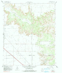
1965 Map of Slaton NE
USGS Topo · Published 1991About this map
The North Fork Double Mountain Fork Brazos River carves a deep, winding path through the High Plains, defining the dramatic topography of Yellow House Canyon. This 1965 survey, updated via photoinspection in 1979, illustrates the transition from the expanding Slaton corporate boundary to the sprawling cattle operations of the Texas South Plains. Large-scale landholdings like Forrest Ranch, Wood Ranch, and Lucy K Ranch dominate the rugged breaks of the canyon, while the flatter uplands are marked by an emerging infrastructure of industrial pipelines and a local Radio Tower. The intersection of Lubbock, Crosby, Lynn, and Garza counties appears here, providing a clear view of how political boundaries and ranch lines, often indicated by specific fence lines, were laid out across this geographic crossroads. Smaller tributaries like Spring Creek and Long Hollow Canyon feed into the river system, supporting the region's long-standing ranching economy.
Find a feature on this map
20 named features on this map. Tap any name to fly to it.
Don’t see what you’re looking for? This feature index may not catch every label — zoom into the map to look around manually.
Map Details
Editions of this 1965 Slaton NE Map
2 editions found
Other maps of this area

1954 · Lubbock
USGS Topo · 1:250,000

1965 · Acuff
USGS Topo · 1:24,000

1965 · Slaton
USGS Topo · 1:24,000

1965 · Buffalo Springs Lake
USGS Topo · 1:24,000

1965 · Southland
USGS Topo · 1:24,000

1965 · Wilson
USGS Topo · 1:24,000

1965 · Slaton NE
USGS Topo · 1:24,000

1966 · Cap Rock
USGS Topo · 1:24,000

1967 · Savage
USGS Topo · 1:24,000

1968 · South Dokegood Creek
USGS Topo · 1:24,000