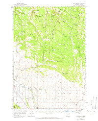
1957 Map of Sled Springs
USGS Topo · Published 1965About this map
The Lostine River valley serves as the primary corridor for human activity in this corner of the Wallowa National Forest. Following the river's path, the Union Pacific Railroad links the small settlements of Lostine and Evans, supporting the local economy of the late 1950s. The landscape is defined by its water resources and high-elevation drainage, with numerous named points such as Five Dollar Spring, Yellow Jacket Spring, and Fourth of July Spring feeding the complex creek systems. While the valleys host ranching operations like the Feagin Ranch and vital services such as the Lostine Cem, the higher ground is dedicated to forest management and recreation. Landmarks like the Sled Springs Guard Sta and Summit Spring Forest Camp indicate the active stewardship of the timberlands, while the intricate network of ridges, including Washboard Ridge and McAllister Ridge, dictates the region's transport and drainage patterns.
Find a feature on this map
57 named features on this map. Tap any name to fly to it.
Don’t see what you’re looking for? This feature index may not catch every label — zoom into the map to look around manually.
Map Details
Editions of this 1957 Sled Springs Map
2 editions found
Other maps of this area

1906 · Telocaset
USGS Topo · 1:125,000

1955 · Grangeville
USGS Topo · 1:250,000

1957 · Enterprise
USGS Topo · 1:62,500

1957 · Joseph
USGS Topo · 1:62,500

1957 · Sled Springs
USGS Topo · 1:62,500

1957 · Elk Mountain
USGS Topo · 1:62,500

1959 · Grangeville
USGS Topo · 1:250,000

1964 · Akers Butte
USGS Topo · 1:24,000

1964 · Wallowa
USGS Topo · 1:24,000

1965 · Fox Point
USGS Topo · 1:24,000