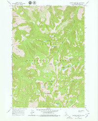
1963 Map of Sleeping Deer Mountain
USGS Topo · Published 1979About this map
Challis National Forest dominates this high-altitude landscape in Lemhi County, centered on the prominent peak of Sleeping Deer Mountain. The topography is defined by a dense network of drainages and alpine basins, where water features like Cache Creek Lakes, Liberty Lakes, and West Fork Lakes collect in the glacial cirques. The 1963 field survey documents a wilderness area largely devoid of permanent infrastructure, with the notable exception of the Cache Creek Cabins situated near the headwaters of Cache Creek.
Find a feature on this map
25 named features on this map. Tap any name to fly to it.
Don’t see what you’re looking for? This feature index may not catch every label — zoom into the map to look around manually.
Map Details
Editions of this 1963 Sleeping Deer Mountain Map
2 editions found
Other maps of this area

1930 · Casto
USGS Topo · 1:125,000

1957 · Challis
USGS Topo · 1:250,000

1960 · Challis
USGS Topo · 1:250,000

1962 · Bear Creek Point
USGS Topo · 1:24,000

1962 · Ramey Hill
USGS Topo · 1:24,000

1963 · Challis
USGS Topo · 1:250,000

1963 · Meyers Cove
USGS Topo · 1:24,000

1963 · Rock Creek
USGS Topo · 1:24,000
1963 · Aparejo Point
USGS Topo · 1:24,000
1963 · Yellowjacket
USGS Topo · 1:24,000