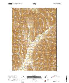
2019 Map of Sleetmute D-2 NE
USGS Topo · Published 2019About this map
The interior of the T22n R40w and T22n R39w townships north of the Kuskokwim River region is defined by a landscape of drainage patterns and topographical relief. This 2019 survey, based on Spot satellite imagery and data from the National Hydrography Dataset, illustrates the complex wetland systems and watercourses that bisect the land between T21n R40w and T21n R39w. The map is characterized by a central low-lying corridor of wetlands flanked by rising elevation to the east and west, showing the untouched character of the Alaskan wilderness. Without roads or established settlements, the map documents the natural hydrology and elevation of the Bethel Census Area as it remained in the early 21st century.
Find a feature on this map
4 named features on this map. Tap any name to fly to it.
Don’t see what you’re looking for? This feature index may not catch every label — zoom into the map to look around manually.
Map Details
Editions of this 2019 Sleetmute D-2 NE Map
This is the sole edition of this map. No revisions or reprints were ever made.
Other maps of this area

1950 · Sleetmute
USGS Topo · 1:250,000

1951 · Iditarod
USGS Topo · 1:250,000

1954 · Sleetmute D-1
USGS Topo · 1:63,360

1954 · Sleetmute D-2
USGS Topo · 1:63,360

1954 · Iditarod A-1
USGS Topo · 1:63,360

1954 · Iditarod A-2
USGS Topo · 1:63,360

1954 · Sleetmute
USGS Topo · 1:250,000

1956 · Iditarod
USGS Topo · 1:250,000
2019 · Sleetmute D-2 NW
USGS Topo · 1:25,000
2019 · Sleetmute D-2 SW
USGS Topo · 1:25,000