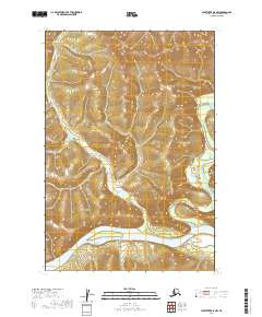
2019 Map of Sleetmute D-5 NW
USGS Topo · Published 2019About this map
The confluence of the George River and the Kuskokwim River anchors this interior Alaskan landscape, where the settlement of Georgetown sits on the northern bank of the Kuskokwim. The terrain is defined by the winding course of Steamboat Cr as it makes its way through the southern sections of the quadrangle. This 2019 survey documents the enduring geography of the Kuskokwim basin, illustrating the relationship between the river systems and the isolated settlements that depend on them for transit and resource access. The map provides a clear look at the township boundaries for t22n r47w, t22n r46w, t21n r47w, and t21n r46w, detailing the elevation and wetlands that characterize this remote stretch of the Bethel Census Area.
Find a feature on this map
8 named features on this map. Tap any name to fly to it.
Don’t see what you’re looking for? This feature index may not catch every label — zoom into the map to look around manually.
Map Details
Editions of this 2019 Sleetmute D-5 NW Map
This is the sole edition of this map. No revisions or reprints were ever made.
Other maps of this area

1950 · Sleetmute
USGS Topo · 1:250,000

1951 · Iditarod
USGS Topo · 1:250,000

1954 · Sleetmute D-5
USGS Topo · 1:63,360

1954 · Sleetmute D-6
USGS Topo · 1:63,360

1954 · Iditarod A-4
USGS Topo · 1:63,360

1954 · Sleetmute
USGS Topo · 1:250,000

1956 · Iditarod
USGS Topo · 1:250,000
2019 · Sleetmute D-5 SW
USGS Topo · 1:25,000
2019 · Sleetmute D-5 NE
USGS Topo · 1:25,000
2019 · Sleetmute D-6 SE
USGS Topo · 1:25,000