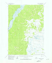
1954 Map of Sleetmute D-8
USGS Topo · Published 1976About this map
The Iditarod River meanders through this portion of the Alaskan interior, defining a landscape shaped by seasonal movement and remote waterways. In the mid-1950s, this area remained largely dominated by its natural drainage systems, including the Kolmakof River, Quinn Creek, and Rainy Creek. A notable human imprint on the terrain is the Winter Trail, which underscores the historical reliance on frozen ground and river corridors for transport in this subarctic environment. Topographic control is anchored by the VABM East Base 1619 geodetic marker, while the vast wetlands and muskeg surrounding Little Creek illustrate the complex hydrology typical of the region before modern development. This document provides a record of the wilderness as it was captured via aerial photography in 1953, reflecting the state of the territory just years before statehood.
Find a feature on this map
7 named features on this map. Tap any name to fly to it.
Don’t see what you’re looking for? This feature index may not catch every label — zoom into the map to look around manually.
Map Details
Editions of this 1954 Sleetmute D-8 Map
2 editions found
Other maps of this area

1947 · Russian Mission
USGS Topo · 1:250,000

1950 · Russian Mission
USGS Topo · 1:250,000

1950 · Sleetmute
USGS Topo · 1:250,000

1951 · Holy Cross
USGS Topo · 1:250,000

1951 · Iditarod
USGS Topo · 1:250,000

1952 · Holy Cross A-1
USGS Topo · 1:63,360

1952 · Russian Mission C-1
USGS Topo · 1:63,360

1952 · Holy Cross
USGS Topo · 1:250,000

1952 · Russian Mission D-1
USGS Topo · 1:63,360
1954 · Sleetmute C-8
USGS Topo · 1:63,360