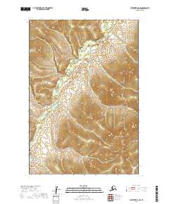
2019 Map of Sleetmute D-8 NW
USGS Topo · Published 2019About this map
The Iditarod River meanders through this section of the Bethel Census Area, defining the drainage patterns of the surrounding wetland and upland terrain. This 2019 survey documents a landscape of significant relief, where elevation gains in the eastern and western portions of the quadrangle frame the lower river valley. Small tributaries such as Quinn Cr feed into the primary waterway, illustrating the complex hydrography of the Alaskan interior. The map clearly delineates the Public Land Survey System boundaries, including t22n r53w and t21n r52w, which are essential for understanding land divisions and property history in this remote region. This document serves as a modern baseline for tracing the geography of the historic Iditarod corridor.
Find a feature on this map
6 named features on this map. Tap any name to fly to it.
Don’t see what you’re looking for? This feature index may not catch every label — zoom into the map to look around manually.
Map Details
Editions of this 2019 Sleetmute D-8 NW Map
This is the sole edition of this map. No revisions or reprints were ever made.
Other maps of this area

1947 · Russian Mission
USGS Topo · 1:250,000

1950 · Russian Mission
USGS Topo · 1:250,000

1950 · Sleetmute
USGS Topo · 1:250,000

1951 · Holy Cross
USGS Topo · 1:250,000

1951 · Iditarod
USGS Topo · 1:250,000

1952 · Holy Cross A-1
USGS Topo · 1:63,360

1952 · Holy Cross
USGS Topo · 1:250,000

1952 · Russian Mission D-1
USGS Topo · 1:63,360
1954 · Sleetmute D-8
USGS Topo · 1:63,360

1954 · Iditarod A-6
USGS Topo · 1:63,360