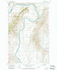
1965 Map of Sloan
USGS Topo · Published 1987About this map
The Flathead River carves a massive arc through this 1965 landscape, defining the boundary between Lake Co and Sanders Co. The terrain is dominated by the Moiese Hills and the dramatic river bend known as The Oxbow. This era reveals an extensive network of water management infrastructure, including the Pablo Canal, Moiese Canal, and specialized features like the Moiese Flume, which speak to the area's agricultural development.
Find a feature on this map
21 named features on this map. Tap any name to fly to it.
Don’t see what you’re looking for? This feature index may not catch every label — zoom into the map to look around manually.
Map Details
Editions of this 1965 Sloan Map
2 editions found
Other maps of this area

1920 · Flathead Lake
USGS Topo · 1:125,000

1956 · Wallace
USGS Topo · 1:250,000

1960 · Wallace
USGS Topo · 1:250,000

1964 · Dixon
USGS Topo · 1:24,000

1964 · Mc Donald
USGS Topo · 1:24,000

1964 · Melton Ranch
USGS Topo · 1:24,000

1964 · Lower Crow Reservoir
USGS Topo · 1:24,000

1964 · Ravalli
USGS Topo · 1:24,000

1965 · Sloan
USGS Topo · 1:24,000

1965 · Oliver Point
USGS Topo · 1:24,000