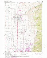
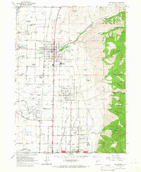
1964 Map of Smithfield
USGS Topo · Published 1986About this map
Agricultural life in the Cache Valley meets the growing institutional footprint of northern Utah in this mid-1960s study, updated through the mid-1980s. The Union Pacific railroad acts as a spine through the valley floor, connecting the primary settlements of Smithfield, Hyde Park, and North Logan. The transition from the flat, irrigated valley to the steep canyons of the Wasatch-Cache National Forest is stark, with the eastern bench land hosting specialized sites like the Green Canyon Forest Nursery and the Municipal Golf Course. Educational and industrial expansion is evident near the southern border with the presence of Utah State University and the Sky View High Sch. Ge genealogists may find interest in the distinct residential layout of White Horse Village and the smaller enclave of Greenville, while aviation researchers can trace the early configuration of the Logan-Cache Airport.
Find a feature on this map
42 named features on this map. Tap any name to fly to it.
Don’t see what you’re looking for? This feature index may not catch every label — zoom into the map to look around manually.
Map Details
Editions of this 1964 Smithfield Map
4 editions found
Other maps of this area

1914 · Logan
USGS Topo · 1:125,000

1916 · Logan
USGS Topo · 1:125,000

1954 · Ogden
USGS Topo · 1:250,000

1958 · Ogden
USGS Topo · 1:250,000

1960 · Ogden
USGS Topo · 1:250,000

1961 · Logan
USGS Topo · 1:24,000
1962 · Wellsville
USGS Topo · 1:24,000
1964 · Smithfield
USGS Topo · 1:24,000
1964 · Richmond
USGS Topo · 1:24,000
1964 · Newton
USGS Topo · 1:24,000