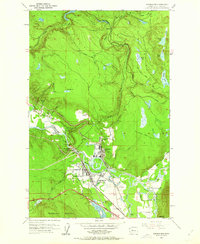
1953 Map of Snoqualmie
USGS Topo · Published 1963About this map
Snoqualmie Falls serves as the focal point of this mid-century landscape, where the Snoqualmie River drops dramatically near a large Lumber Mill and dedicated Powerhouse. The map reveals an industrial and transit corridor transitioning into the foothills, evidenced by the Chicago Milwaukee St Paul and Pacific rail line and several sections of Old Railroad Grade winding through the timber. Small settlements like Spring Glen and Tokul appear alongside essential community infrastructure such as the Mt Si High Sch and the Mt Si Golf Course. The survey also documents the hydraulic complexity of the valley floor, featuring various water bodies like Lake Marie and the meandering Meadowbrook Slough. Traces of local extraction are visible at the Quarry near Ellisville and a Gravel Pit south of the main town site, illustrating the resource-driven economy of the early 1950s.
Find a feature on this map
45 named features on this map. Tap any name to fly to it.
Don’t see what you’re looking for? This feature index may not catch every label — zoom into the map to look around manually.
Map Details
Editions of this 1953 Snoqualmie Map
5 editions found
Other maps of this area

1913 · Cedar Lake
USGS Topo · 1:125,000

1921 · Sultan
USGS Topo · 1:125,000

1923 · Sultan
USGS Topo · 1:125,000

1953 · Snoqualmie
USGS Topo · 1:24,000

1953 · North Bend
USGS Topo · 1:24,000

1953 · Lake Joy
USGS Topo · 1:24,000

1953 · Hobart
USGS Topo · 1:24,000

1953 · Fall City
USGS Topo · 1:24,000

1953 · Carnation
USGS Topo · 1:24,000

1957 · Wenatchee
USGS Topo · 1:250,000