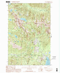
1989 Map of Snoqualmie Pass
USGS Topo · Published 1989About this map
The high mountain corridor of Snoqualmie Pass is captured here as a landscape of recreational development and essential transit during the late 1980s. This survey illustrates the dense concentration of winter sports infrastructure, including the Snoqualmie Summit and the Pacific West Ski Area, adjacent to the vital passage of I-90. The map documents the interface between the Snoqualmie National Forest and the protected Alpine Lakes Wilderness, where high-elevation landmarks like Granite Mountain and Snow Lake overlook the valley floor. Near the settlement of Hyak, the shoreline of Keechelus Lake and the path of the Burlington Northern railroad reflect the historical importance of this gap for interstate commerce. Traces of early forest management and tourism are evident at the Asahel Curtis Picnic Ground and the Denny Creek Campground, showing how this rugged transition between King and Kittitas counties was navigated and utilized before modern expansions.
Find a feature on this map
90 named features on this map. Tap any name to fly to it.
Don’t see what you’re looking for? This feature index may not catch every label — zoom into the map to look around manually.
Map Details
Editions of this 1989 Snoqualmie Pass Map
2 editions found
Other maps of this area

1901 · Snoqualmie Pass
USGS Topo · 1:125,000

1902 · Skykomish
USGS Topo · 1:125,000

1903 · Snoqualmie
USGS Topo · 1:125,000

1905 · Skykomish
USGS Topo · 1:125,000

1913 · Cedar Lake
USGS Topo · 1:125,000

1921 · Sultan
USGS Topo · 1:125,000

1923 · Sultan
USGS Topo · 1:125,000

1957 · Wenatchee
USGS Topo · 1:250,000

1960 · Mount Si
USGS Topo · 1:62,500

1960 · Bandera
USGS Topo · 1:62,500