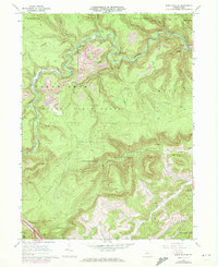
1960 Map of Snow Shoe SE
USGS Topo · Published 1972About this map
Orviston and Kato anchor this central Pennsylvania landscape, where industrial activity and conservation efforts met during the late mid-century. The Penn Central railroad winds through the steep terrain, utilizing the Hogback Tunnel to traverse the ridges above Beech Creek. While much of the territory is protected as part of the Sproul State Forest, the presence of numerous Strip Mine sites and a Pipeline indicates a region heavily defined by natural resource extraction.
Find a feature on this map
36 named features on this map. Tap any name to fly to it.
Don’t see what you’re looking for? This feature index may not catch every label — zoom into the map to look around manually.
Map Details
Editions of this 1960 Snow Shoe SE Map
4 editions found
Other maps of this area

1908 · Bellefonte
USGS Topo · 1:62,500

1909 · Bellefonte
USGS Topo · 1:62,500

1921 · Howard
USGS Topo · 1:48,000

1923 · Howard
USGS Topo · 1:62,500

1924 · Centre Hall
USGS Topo · 1:62,500

1928 · Snow Shoe
USGS Topo · 1:48,000

1929 · Centre Hall
USGS Topo · 1:62,500

1931 · Show Shoe
USGS Topo · 1:62,500

1943 · Lewistown
USGS Topo · 1:125,000

1950 · Harrisburg
USGS Topo · 1:250,000