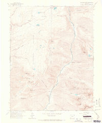
1964 Map of Snowdon Peak
USGS Topo · Published 1967About this map
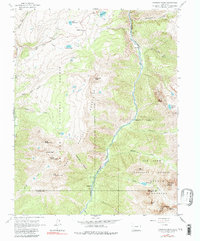
The Animas River corridor serves as the primary artery through this high-altitude landscape within the San Juan National Forest. During the mid-1960s, the Denver and Rio Grande Western Railroad remained the critical transit link through the canyon, supporting the small settlement of Needleton and the nearby Needleton Water Tank. This survey captures the remote intersection of the Grenadier Range and the Needle Mountains, characterized by sharp peaks such as Mount Garfield, Snowdon Peak, and Pigeon Peak. To the west, the landscape is punctuated by alpine waters like Molas Lake and Andrews Lake near Molas Pass, where Highway 550 winds through the high country. The map illustrates the concentration of human activity along the river valley and the rail line, contrasted against the massive, unnamed reaches of the high San Juan summits.
Find a feature on this map
46 named features on this map. Tap any name to fly to it.
Don’t see what you’re looking for? This feature index may not catch every label — zoom into the map to look around manually.
Map Details
Editions of this 1964 Snowdon Peak Map
5 editions found
Other maps of this area

1897 · Telluride
USGS Topo · 1:62,500

1897 · Silverton
USGS Topo · 1:62,500

1898 · Engineer Mountain
USGS Topo · 1:62,500

1900 · Engineer Mountain
USGS Topo · 1:62,500

1900 · Needle Mountains
USGS Topo · 1:62,500

1901 · Silverton
USGS Topo · 1:62,500

1902 · Needle Mountains
USGS Topo · 1:62,500

1902 · Silverton
USGS Topo · 1:62,500

1904 · Telluride
USGS Topo · 1:62,500

1908 · Engineer Mountain
USGS Topo · 1:62,500