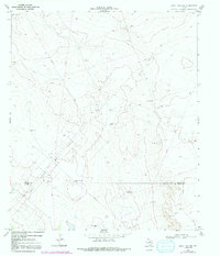
1967 Map of Soda Lake NW
USGS Topo · Published 1991About this map
Energy production and cattle ranching define this arid stretch of West Texas along the boundary of Loving Co Ward Co. Based on 1967 photography with 1979 revisions, the landscape is heavily marked by the infrastructure of the Two Fred's Field and Meridian Oil Field. The distribution of scattered resources like High Lonesome Well, Red Tank Windmill, and Fence Windmill reflects the critical importance of water management in this desert environment. Small-scale industrial activity is evident at several Gravel Pit locations, supporting the network of service roads and pipelines that crisscross the terrain. The map captures a moment when traditional ranching landmarks, such as the Farm Well and Humble Well, began to coexist with an intensifying grid of petroleum exploration near the Ward County line.
Find a feature on this map
12 named features on this map. Tap any name to fly to it.
Don’t see what you’re looking for? This feature index may not catch every label — zoom into the map to look around manually.
Map Details
Editions of this 1967 Soda Lake NW Map
3 editions found
Other maps of this area

1954 · Pecos
USGS Topo · 1:250,000

1957 · Pecos
USGS Topo · 1:250,000

1961 · Soda Lake
USGS Topo · 1:24,000

1961 · Mentone
USGS Topo · 1:24,000

1961 · Sand Lake
USGS Topo · 1:24,000

1967 · Soda Lake NW
USGS Topo · 1:24,000

1968 · Soda Lake SE
USGS Topo · 1:24,000

1968 · Soda Lake NE
USGS Topo · 1:24,000

1969 · Cheyenne Draw SW
USGS Topo · 1:24,000
1969 · Rudd Draw
USGS Topo · 1:24,000