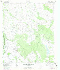
1961 Map of Soda Lake
USGS Topo · Published 1981About this map
Energy production and irrigation infrastructure dominate this West Texas landscape along the border of Reeves and Ward counties. The Pecos River serves as the primary water source, feeding the intricate network of the Barstow Canal and Cedarvale Canal that cut through the arid terrain. The map captures the industrial character of the mid-century Permian Basin, defined by the expansive Monroe Oil Field and West Quito Field, where numerous Oil Wells and a complex Pipeline network indicate active petroleum extraction. A solitary grave and the Donegan Ranch provide evidence of early settlement and ranching life in the vicinity of the ephemeral Soda Lake. The landscape is a study in how water management and mineral wealth shaped the development of this corner of the state, from the Quarry in the south to the high-voltage Substation and Tower infrastructure supporting local power needs.
Find a feature on this map
14 named features on this map. Tap any name to fly to it.
Don’t see what you’re looking for? This feature index may not catch every label — zoom into the map to look around manually.
Map Details
Editions of this 1961 Soda Lake Map
3 editions found
Other maps of this area

1921 · Toyah
USGS Topo · 1:125,000

1931 · Barstow
USGS Topo · 1:125,000

1954 · Pecos
USGS Topo · 1:250,000

1957 · Pecos
USGS Topo · 1:250,000

1961 · Soda Lake
USGS Topo · 1:24,000

1961 · Mentone
USGS Topo · 1:24,000

1961 · Sand Lake
USGS Topo · 1:24,000

1963 · Quito Draw
USGS Topo · 1:24,000

1963 · Pecos East
USGS Topo · 1:24,000

1967 · Soda Lake NW
USGS Topo · 1:24,000