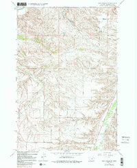
1967 Map of Soda Springs NW
USGS Topo · Published 1981About this map
Indian Caves State Park and the rugged northern reaches of the Crow Indian Reservation define this transition from the Yellowstone River valley into the broken coulee country of Montana. This 1967 survey depicts a landscape shaped by narrow drainage systems and steep topography, where the Billings Racetrack sits just north of the winding Bitter Creek. The map captures the rural infrastructure of the era, from the isolated Morin Sch in the southeast to the Pipeline cutting across the central hills. Significant watercourses like Blue Creek, Pryor Creek, and West Buckeye Creek dictate the settlement patterns and road networks through the valleys. The prominence of family-named or locally identified terrain, such as Cashen Coulee and Sue Jane Coulee, provides specific landmarks for genealogists and local historians tracing the development of Yellowstone County during the mid-twentieth century.
Find a feature on this map
16 named features on this map. Tap any name to fly to it.
Don’t see what you’re looking for? This feature index may not catch every label — zoom into the map to look around manually.
Map Details
Editions of this 1967 Soda Springs NW Map
3 editions found
Other maps of this area

1893 · Huntley
USGS Topo · 1:125,000

1954 · Billings
USGS Topo · 1:250,000

1956 · Yegen
USGS Topo · 1:24,000

1956 · Billings East
USGS Topo · 1:24,000

1957 · Billings
USGS Topo · 1:250,000

1957 · Billings West
USGS Topo · 1:24,000

1958 · Billings
USGS Topo · 1:250,000

1967 · Soda Springs NW
USGS Topo · 1:24,000

1967 · Soda Springs
USGS Topo · 1:24,000

1967 · Cottonwood Creek
USGS Topo · 1:24,000