
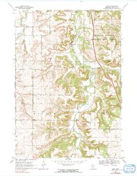
1968 Map of Sogn
USGS Topo · Published 1970About this map
The Little Cannon River carves a deep valley through the limestone bluffs of Goodhue County, defining the rural character of this late 1960s landscape. Much of the eastern terrain is protected within the Minnesota Memorial Hardwood State Forest, where the topography transitions from flat upland farm fields into the steep ravines of Butler Creek. These hillsides are dotted with the cultural markers of Norwegian and Scandinavian settlement, including the Wangen Prairie Ch and the Urland Ch.
Find a feature on this map
22 named features on this map. Tap any name to fly to it.
Don’t see what you’re looking for? This feature index may not catch every label — zoom into the map to look around manually.
Map Details
Editions of this 1968 Sogn Map
2 editions found
Other maps of this area

1953 · Saint Paul
USGS Topo · 1:250,000

1957 · Farmington
USGS Topo · 1:62,500

1957 · Hastings
USGS Topo · 1:62,500

1959 · Saint Paul
USGS Topo · 1:250,000

1960 · Dennison
USGS Topo · 1:24,000

1960 · Nerstrand
USGS Topo · 1:24,000

1968 · Kenyon
USGS Topo · 1:24,000

1968 · Wanamingo
USGS Topo · 1:24,000

1968 · White Rock
USGS Topo · 1:24,000
1974 · Randolph
USGS Topo · 1:24,000