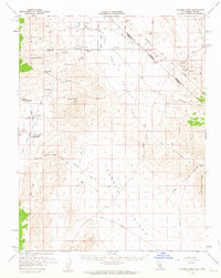
1958 Map of Soldier Pass
USGS Topo · Published 1963About this map
White Mts and the high desert basins of the Fish Lake Valley and Eureka Valley dominate this late 1950s survey of the California-Nevada border. The landscape is defined by its isolation and specialized land use, ranging from the academic outpost of Deep Springs Jr College to the remnants of earlier mining and settlement efforts. Traces of indigenous history appear near the White Mts where petroglyphs are recorded, while the industrial character of the era is marked by several mineral claims, including the Sierra Talc Mine, Buck Mine, and Victor Cons Mine. The survey precisely follows the Von Schmidt Line, illustrating the historical boundary between the two states as it cuts through the Sylvania Mts. Notable ruins like White Mtn City and small settlements such as Oasis provide key data points for those studying the progression of Great Basin settlement and desert agriculture.
Find a feature on this map
37 named features on this map. Tap any name to fly to it.
Don’t see what you’re looking for? This feature index may not catch every label — zoom into the map to look around manually.
Map Details
Editions of this 1958 Soldier Pass Map
2 editions found

Other maps of this area

1898 · Silver Peak
USGS Topo · 1:125,000

1900 · Silver Peak
USGS Topo · 1:125,000

1908 · Lida
USGS Topo · 1:250,000

1913 · Bishop
USGS Topo · 1:125,000

1913 · Lida
USGS Topo · 1:250,000

1917 · White Mountain
USGS Topo · 1:125,000

1947 · Mariposa
USGS Topo · 1:250,000

1948 · Mariposa
USGS Topo · 1:250,000

1951 · Blanco Mountain
USGS Topo · 1:62,500

1951 · Waucoba Mtn.
USGS Topo · 1:62,500