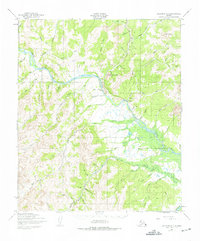
1950 Map of Solomon D-4
USGS Topo · Published 1975About this map
The Niukluk River serves as the central artery for this Seward Peninsula landscape, anchoring the settlement of Council. This area, documented by the Army Map Service in 1950, shows a network of remote transportation routes including a Railroad Grade and several Tractor Trails that once supported the local mining economy. The presence of specialized infrastructure like the Council Mine Landing Strip, Melsing Landing Strip, and Fox Bar Landing Strip highlights the reliance on bush aviation for reaching isolated claims and camps. Significant elevations such as Mount Mordaunt and King Mountain overlook a complex drainage system where Melsing Creek, Warm Creek, and Dutch Creek meet the river. The map also records numerous cabins and a Gravel Pit, providing a detailed look at human activity in the Alaskan interior during the mid-20th century.
Find a feature on this map
57 named features on this map. Tap any name to fly to it.
Don’t see what you’re looking for? This feature index may not catch every label — zoom into the map to look around manually.
Map Details
Editions of this 1950 Solomon D-4 Map
2 editions found

Other maps of this area

1907 · Casadepaga
USGS Topo · 1:62,500

1907 · Solomon
USGS Topo · 1:62,500

1950 · Bendeleben A-4
USGS Topo · 1:63,360

1950 · Bendeleben A-5
USGS Topo · 1:63,360

1950 · Bendeleben A-3
USGS Topo · 1:63,360

1950 · Solomon C-5
USGS Topo · 1:63,360

1950 · Solomon C-4
USGS Topo · 1:63,360

1950 · Bendeleben
USGS Topo · 1:250,000

1950 · Solomon D-3
USGS Topo · 1:63,360

1950 · Solomon
USGS Topo · 1:250,000