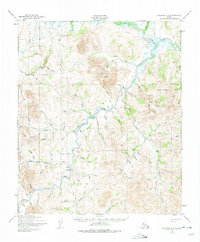
1950 Map of Solomon D-5
USGS Topo · Published 1975About this map
The Niukluk River and Casadepaga River systems dominate this interior Alaskan landscape, which was mapped in the mid-20th century. At this time, the region's transport network was a patchwork of specialized routes designed for sub-arctic logistics, including an Old Railroad Grade and sections of Corduroy Road suitable for heavy equipment. For travel across the muskeg and snow, several stretches of Tractor Trail and Winter Trail connect isolated outposts. Remote outposts like Ruby Roadhouse and various scattered cabins provide evidence of the mining and trapping activities that defined the Seward Peninsula economy. The presence of three separate landing strips, including the American Creek Landing Strip and a grass-surface Landing Strip, highlights the area's dependence on bush planes for supplies and travel between the high ridges of Mount Dixon and the river basins.
Find a feature on this map
77 named features on this map. Tap any name to fly to it.
Don’t see what you’re looking for? This feature index may not catch every label — zoom into the map to look around manually.
Map Details
Editions of this 1950 Solomon D-5 Map
3 editions found

Other maps of this area

1907 · Casadepaga
USGS Topo · 1:62,500

1907 · Solomon
USGS Topo · 1:62,500

1950 · Bendeleben A-6
USGS Topo · 1:63,360

1950 · Bendeleben A-4
USGS Topo · 1:63,360

1950 · Bendeleben A-5
USGS Topo · 1:63,360

1950 · Solomon C-5
USGS Topo · 1:63,360

1950 · Solomon C-6
USGS Topo · 1:63,360

1950 · Solomon C-4
USGS Topo · 1:63,360

1950 · Bendeleben
USGS Topo · 1:250,000

1950 · Solomon
USGS Topo · 1:250,000