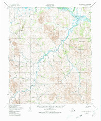
1950 Map of Solomon D-5
USGS Topo · Published 1980About this map
The Niukluk River and Casadepaga River confluence defines this remote interior landscape of the Seward Peninsula, captured during 1950 aerial surveys. The map documents a territory transitioning from its early mining boom toward mid-century aviation reliance, evidenced by the presence of the American Creek Landing Strip and Bonanza Creek Landing Strip. Transportation history is etched into the terrain through the Corduroy Road Old Railroad Grade and other remnants of a Railroad Grade that once served the local gold-bearing creeks.
Find a feature on this map
84 named features on this map. Tap any name to fly to it.
Don’t see what you’re looking for? This feature index may not catch every label — zoom into the map to look around manually.
Map Details
Editions of this 1950 Solomon D-5 Map
3 editions found

Other maps of this area

1907 · Casadepaga
USGS Topo · 1:62,500

1907 · Solomon
USGS Topo · 1:62,500

1950 · Bendeleben A-6
USGS Topo · 1:63,360

1950 · Bendeleben A-4
USGS Topo · 1:63,360

1950 · Bendeleben A-5
USGS Topo · 1:63,360

1950 · Solomon C-5
USGS Topo · 1:63,360

1950 · Solomon C-6
USGS Topo · 1:63,360

1950 · Solomon C-4
USGS Topo · 1:63,360

1950 · Bendeleben
USGS Topo · 1:250,000

1950 · Solomon
USGS Topo · 1:250,000