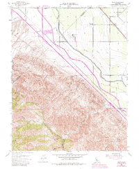
1953 Map of Solyo
USGS Topo · Published 1984About this map
Solyo and its surrounding agricultural corridor sit at the junction of massive water infrastructure and historical rail transport. The landscape is dominated by the parallel routes of the California Aqueduct, the Delta-Mendota Canal, and the Hetch Hetchy Aqueduct, illustrating the mid-century engineering required to manage Central Valley water resources. In the north, the El Pescadero (Grimes) Grant Bdy marks the enduring legacy of Spanish and Mexican land grants. To the southwest, the terrain rises sharply toward Mt. Oso, where numerous drainages like Ingram Canyon and Hospital Creek carve through the foothills. This 1953 survey, with revisions into the 1970s, captures a transition where traditional landmarks like the Rising Sun School and the Southern Pacific tracks coexist with expanding modern utility corridors and a large Gravel Pit.
Find a feature on this map
32 named features on this map. Tap any name to fly to it.
Don’t see what you’re looking for? This feature index may not catch every label — zoom into the map to look around manually.
Map Details
Editions of this 1953 Solyo Map
4 editions found
Other maps of this area

1913 · Romain
USGS Topo · 1:31,680

1915 · Vernalis
USGS Topo · 1:31,680

1915 · Ripon
USGS Topo · 1:31,680

1915 · Westley
USGS Topo · 1:31,680

1916 · Patterson
USGS Topo · 1:31,680

1916 · Tracy
USGS Topo · 1:31,680

1916 · Romain
USGS Topo · 1:31,680

1919 · Orestimba
USGS Topo · 1:62,500

1922 · Carbona
USGS Topo · 1:62,500

1938 · Mt. Boardman
USGS Topo · 1:62,500