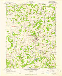
1961 Map of Somerset
USGS Topo · Published 1963About this map
Somerset serves as the focal point of this Perry County landscape during the early 1960s, situated at the junction of several regional routes. The map documents an area defined by its diverse economic activities, from traditional agriculture to extractive industries. Scattered oil wells and gas wells dot the townships of Thorn, Hopewell, and Reading, while the southeastern corner shows active strip mines. The Baltimore and Ohio Railroad provides a critical transit corridor, passing through Chalfants and near a local fairground. Cultural and religious landmarks are well-represented, including St Josephs Priory and several small rural burial grounds like Ream Cem and Brehm Cem. Water features such as Somerset Reservoir and the Clouse Lake Wildlife Area reflect the local infrastructure and conservation efforts of the era.
Find a feature on this map
41 named features on this map. Tap any name to fly to it.
Don’t see what you’re looking for? This feature index may not catch every label — zoom into the map to look around manually.
Map Details
Editions of this 1961 Somerset Map
3 editions found
Other maps of this area

1907 · Logan
USGS Topo · 1:62,500

1909 · Thornville
USGS Topo · 1:62,500

1909 · Logan
USGS Topo · 1:62,500

1910 · Zanesville
USGS Topo · 1:62,500

1911 · New Lexington
USGS Topo · 1:62,500

1947 · Columbus
USGS Topo · 1:250,000

1961 · Columbus
USGS Topo · 1:250,000

1961 · Rushville
USGS Topo · 1:24,000
1961 · Thornville
USGS Topo · 1:24,000

1961 · New Lexington
USGS Topo · 1:24,000