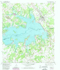
1971 Map of Somerville
USGS Topo · Published 1989About this map
Somerville Lake dominates the central landscape of this 1970s survey, illustrating the transformation of the Yegua Creek basin following the construction of the Somerville Dam. The map documents the extensive recreational infrastructure developed around the reservoir, including Birch Creek State Park, Welch Park, and Big Creek Park. North of the water, the town of Somerville remains a primary hub, while the surrounding countryside is dotted with legacy family sites and rural landmarks. Genealogists will find a high density of burial grounds such as Schoppe Cem, Williams Cem, and Graveyard Crossing Cem. The map also captures the industrial footprint of the era through scattered oil fields and numerous oil wells north of Rehburg and west of the main town, alongside physical features like Shepherd Mountain and Green Mountain.
Find a feature on this map
45 named features on this map. Tap any name to fly to it.
Don’t see what you’re looking for? This feature index may not catch every label — zoom into the map to look around manually.
Map Details
Editions of this 1971 Somerville Map
3 editions found
Other maps of this area

1914 · Gay Hill
USGS Topo · 1:62,500

1930 · Brenham
USGS Topo · 1:62,500

1954 · Austin
USGS Topo · 1:250,000

1956 · Brenham
USGS Topo · 1:62,500

1956 · Somerville
USGS Topo · 1:62,500

1958 · Carmine
USGS Topo · 1:24,000

1958 · Burton
USGS Topo · 1:24,000

1959 · Flag Pond
USGS Topo · 1:24,000

1959 · Gay Hill
USGS Topo · 1:24,000

1959 · Somerville
USGS Topo · 1:24,000