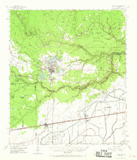
1955 Map of Sour Lake
USGS Topo · Published 1970About this map
Sour Lake Oil Field and the surrounding piney woods define this mid-century landscape at the junction of Hardin, Liberty, and Jefferson counties. The town of Sour Lake sits atop the notable Sour Lake Dome, a geologic feature that drove the region's early petroleum boom. The map captures a dense network of energy infrastructure, including numerous oil wells and pipelines, juxtaposed against traditional settlement patterns. Local history is preserved in rural landmarks like Pine Ridge Ch and its neighboring Pine Ridge Cem, as well as the Henderson Sch near the community of China.
Find a feature on this map
61 named features on this map. Tap any name to fly to it.
Don’t see what you’re looking for? This feature index may not catch every label — zoom into the map to look around manually.
Map Details
Editions of this 1955 Sour Lake Map
2 editions found

Other maps of this area

1932 · Beaumont
USGS Topo · 1:62,500

1943 · Whites Bayou
USGS Topo · 1:24,000

1943 · Liberty
USGS Topo · 1:125,000

1943 · Fannett East
USGS Topo · 1:24,000

1945 · Fannett East
USGS Topo · 1:31,680

1945 · Nolte
USGS Topo · 1:31,680

1950 · Houston
USGS Topo · 1:250,000

1954 · Beaumont
USGS Topo · 1:250,000

1955 · Daisetta
USGS Topo · 1:62,500

1955 · Saratoga
USGS Topo · 1:62,500