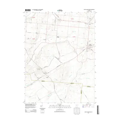
2013 Map of South Charleston
USGS Topo · Published 2013About this map
South Charleston serves as the primary hub of this landscape, situated at the intersection of several regional thoroughfares including the S Charleston Pike and Us-42. The area is defined by its transition between agricultural fields and the riparian corridors of the Little Miami River and the N Fork Massies Cr. Smaller hamlets and historically significant junctions are scattered throughout the quadrangle, including Lisbon, Selma, and the notably named Dolly Varden. For genealogists and local historians, the map provides precise locations for several cemeteries, such as the Old Quaker Cem and the Selma Methodist Episcopal Cem, which anchor the rural landscape. The northern portion of the map features the Lisbon Airfield, reflecting the area's modern infrastructure alongside established 19th-century settlement patterns and family-named routes like Buffenbarger Rd.
Find a feature on this map
64 named features on this map. Tap any name to fly to it.
Don’t see what you’re looking for? This feature index may not catch every label — zoom into the map to look around manually.
Map Details
Editions of this 2013 South Charleston Map
This is the sole edition of this map. No revisions or reprints were ever made.
Other maps of this area

1904 · Springfield
USGS Topo · 1:62,500

1906 · Springfield
USGS Topo · 1:62,500

1907 · South Charleston
USGS Topo · 1:62,500

1916 · Octa
USGS Topo · 1:62,500

1917 · Xenia
USGS Topo · 1:62,500

1944 · Octa
USGS Topo · 1:62,500

1947 · Columbus
USGS Topo · 1:250,000

1954 · Clifton
USGS Topo · 1:24,000
1955 · Springfield
USGS Topo · 1:24,000

1955 · Cedarville
USGS Topo · 1:24,000