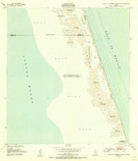
1952 Map of South of Potrero Lopeno SE
USGS Topo · Published 1955About this map
Padre Island stretches across this mid-century survey, revealing a landscape defined by constant movement and coastal change. Located between Laguna Madre and the Gulf of Mexico, the island is characterized by extensive shifting sand dunes and vast sand and mud flats. The survey captures the wild state of the Texas coastline before major recreational development, noting specific dune elevations ranging from two to thirty-five feet.
Find a feature on this map
19 named features on this map. Tap any name to fly to it.
Don’t see what you’re looking for? This feature index may not catch every label — zoom into the map to look around manually.
Map Details
Editions of this 1952 South of Potrero Lopeno SE Map
3 editions found
Other maps of this area

1951 · South of Potrero Lopeno NE
USGS Topo · 1:24,000

1952 · Green Island
USGS Topo · 1:24,000

1952 · South of Potrero Lopeno NW
USGS Topo · 1:24,000
1952 · North Of Port Isabel NW
USGS Topo · 1:24,000

1952 · South of Potrero Lopeno SE
USGS Topo · 1:24,000

1952 · Hawk Island
USGS Topo · 1:24,000

1952 · Port Mansfield
USGS Topo · 1:24,000

1952 · South of Potrero Lopeno
USGS Topo · 1:62,500

1953 · Brownsville
USGS Topo · 1:250,000
1955 · La Leona
USGS Topo · 1:62,500