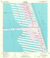
1952 Map of South of Potrero Lopeno SE
USGS Topo · Published 1978About this map
Laguna Madre dominates this mid-century topographic study, capturing the intersection of the Texas mainland waters and the barrier island system. This 1952 survey, updated with 1975 aerial observations, illustrates the engineering of the Port Mansfield Channel, a vital maritime artery cut through the shifting landscape. The transition of this coast is evident in the detailed mapping of Padre Island and its designation within the Padre Island National Seashore. The map highlights the dynamic nature of the South Texas coast, where Shifting Sand Dunes and extensive Sand and Mud Flats define the boundary between the quiet lagoon and the open Gulf of Mexico. The county line between Kenedy Co and Willacy Co bisects the northern reaches of the sheet, providing a precise record of administrative boundaries within this coastal wilderness.
Find a feature on this map
11 named features on this map. Tap any name to fly to it.
Don’t see what you’re looking for? This feature index may not catch every label — zoom into the map to look around manually.
Map Details
Editions of this 1952 South of Potrero Lopeno SE Map
3 editions found
Other maps of this area

1951 · South of Potrero Lopeno NE
USGS Topo · 1:24,000

1952 · Green Island
USGS Topo · 1:24,000

1952 · South of Potrero Lopeno NW
USGS Topo · 1:24,000
1952 · North Of Port Isabel NW
USGS Topo · 1:24,000

1952 · South of Potrero Lopeno SE
USGS Topo · 1:24,000

1952 · Hawk Island
USGS Topo · 1:24,000

1952 · Port Mansfield
USGS Topo · 1:24,000

1952 · South of Potrero Lopeno
USGS Topo · 1:62,500

1953 · Brownsville
USGS Topo · 1:250,000
1955 · La Leona
USGS Topo · 1:62,500