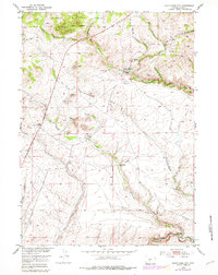
1953 Map of South Pass City
USGS Topo · Published 1979About this map
South Pass City stands as the primary focal point of this mid-century survey, a location deeply tied to the gold mining history of the Wind River Range. The landscape is heavily marked by industrial efforts, with numerous claims including the Duncan Mine, King Solomon Mine, and Barr Mine situated north of the settlement. To the south, the Sweetwater River winds through the terrain, a vital water source for the region's development.
Find a feature on this map
29 named features on this map. Tap any name to fly to it.
Don’t see what you’re looking for? This feature index may not catch every label — zoom into the map to look around manually.
Map Details
Editions of this 1953 South Pass City Map
5 editions found
Other maps of this area

1953 · Atlantic City
USGS Topo · 1:24,000

1953 · Louis Lake
USGS Topo · 1:24,000

1953 · South Pass City
USGS Topo · 1:24,000

1953 · Christina Lake
USGS Topo · 1:24,000

1954 · Miners Delight
USGS Topo · 1:24,000

1955 · Lander
USGS Topo · 1:250,000

1958 · Lander
USGS Topo · 1:250,000

1958 · Pacific Springs
USGS Topo · 1:24,000

1958 · Dickie Springs
USGS Topo · 1:24,000

1958 · Continental Peak
USGS Topo · 1:24,000