
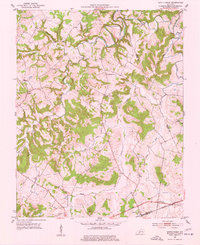
1951 Map of South Union
USGS Topo · Published 1953About this map
South Union sits at the southern edge of this mid-century Logan County landscape, where the Louisville and Nashville railroad and the Louisville and Nashville Highway parallel one another through the hills. This 1951 field check records a rural network of churches and schools that served the local farming communities, including New Harmony Ch, Cave Spring Ch, and the St Maur Sch. The drainage of the Gasper River dominates the western half of the map, carving deep hollows like Shaker Hollow and Epperson Hollow into the terrain. Traces of early industrial activity are present in the form of scattered Oil Wells and a Quarry, while family history is preserved at the Gasper River Cem and Felts Cem. The map provides a detailed view of the winding boundaries between Logan, Warren, and Simpson counties as they existed before modern development altered the rural character of the region.
Find a feature on this map
26 named features on this map. Tap any name to fly to it.
Don’t see what you’re looking for? This feature index may not catch every label — zoom into the map to look around manually.
Map Details
Editions of this 1951 South Union Map
2 editions found
Other maps of this area

1911 · Dunmor
USGS Topo · 1:48,000

1914 · Little Muddy
USGS Topo · 1:62,500

1914 · Dunmor
USGS Topo · 1:62,500

1951 · Woodburn
USGS Topo · 1:24,000

1951 · Auburn
USGS Topo · 1:24,000

1951 · Homer
USGS Topo · 1:24,000

1952 · Dennis
USGS Topo · 1:24,000

1952 · Rockfield
USGS Topo · 1:24,000

1953 · Quality
USGS Topo · 1:24,000

1954 · Evansville
USGS Topo · 1:250,000