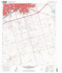
1965 Map of Southeast Midland
USGS Topo · Published 1975About this map
Midland expands southward from the Texas and Pacific railroad corridor in this mid-1960s survey, reflecting a period of significant growth and infrastructural development. While the urban core is dense with civic landmarks like City Hall, the Post Office, and various educational sites such as Bunche Sch and Travis Sch, the landscape transitions into a network of industrial and agricultural utility. To the south, the community of Cotton Flat and its nearby Cotton Flat Ch mark the shift toward open terrain, where Monahans Draw winds through the Permian Basin floor. The presence of Rattlesnake Raceway and numerous Radio Towers highlights the mid-century modernization of the area, while smaller residential pockets like Sandy Acres and Ridgeheights begin to populate the spaces between the oil-related economy's Quarries and Gravel Pits.
Find a feature on this map
35 named features on this map. Tap any name to fly to it.
Don’t see what you’re looking for? This feature index may not catch every label — zoom into the map to look around manually.
Map Details
Editions of this 1965 Southeast Midland Map
3 editions found

Other maps of this area

1954 · Hobbs
USGS Topo · 1:250,000

1954 · Pecos
USGS Topo · 1:250,000

1954 · Big Spring
USGS Topo · 1:250,000

1954 · San Angelo
USGS Topo · 1:250,000

1957 · Pecos
USGS Topo · 1:250,000

1958 · San Angelo
USGS Topo · 1:250,000

1958 · Big Spring
USGS Topo · 1:250,000

1958 · Hobbs
USGS Topo · 1:250,000

1964 · Bryant Ranch
USGS Topo · 1:24,000

1964 · Parks
USGS Topo · 1:24,000