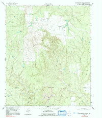
1958 Map of Southerland Canyon
USGS Topo · Published 1991About this map
Bar S Ranch (Headquarters) anchor this western Texas landscape, a region defined by ranching and the complex drainage systems of the Brazos River watershed. The terrain is marked by significant elevation changes, most notably at Haystack Mountain, which overlooks a series of deep cuts including Southerland Canyon and Panther Canyon. The mapping reveals a sparse but vital network of water resources essential for livestock, from the winding North Croton Creek and Salt Flat Creek to isolated landmarks like the Hackberry Windmill and Negro Tank. An Indefinite Boundary separates King and Stonewall counties, reflecting the difficulty of surveying this dissected topography during the mid-century period. This 1958 survey captures the ranching economy before modern infrastructure, where cattle tanks and named springs were the primary markers of human presence in the brush country.
Find a feature on this map
19 named features on this map. Tap any name to fly to it.
Don’t see what you’re looking for? This feature index may not catch every label — zoom into the map to look around manually.
Map Details
Editions of this 1958 Southerland Canyon Map
2 editions found
Other maps of this area

1954 · Lubbock
USGS Topo · 1:250,000

1958 · Pursley House
USGS Topo · 1:24,000

1958 · Southerland Canyon
USGS Topo · 1:24,000

1958 · Seven Diamond L Canyon
USGS Topo · 1:24,000

1958 · Lovers Resort
USGS Topo · 1:24,000

1958 · Jayton
USGS Topo · 1:24,000

1959 · Bob Creek
USGS Topo · 1:24,000

1968 · Pitchfork Ranch
USGS Topo · 1:24,000

1968 · Guthrie
USGS Topo · 1:24,000

1968 · Pitchfork Flats
USGS Topo · 1:24,000