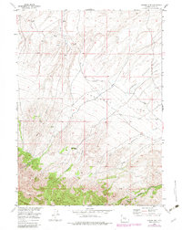
1953 Map of Spanish Mine
USGS Topo · Published 1982About this map
The Spanish Mine sits at the northern edge of the Ferris Mountains, marking a landscape defined by sharp elevation shifts and the essential management of water. This 1953 survey, updated with 1980 aerial data, reveals a network of ditches and pipelines cutting across the Arkansas Flats, indicating the vital role of irrigation and resource transport in this high-altitude environment. Several drainage systems, including Rush Creek and Arkansas Creek, flow northward from the mountain front, while named canyons like Pole Canyon and Miners Canyon carve through the southern slopes.
Find a feature on this map
9 named features on this map. Tap any name to fly to it.
Don’t see what you’re looking for? This feature index may not catch every label — zoom into the map to look around manually.
Map Details
Editions of this 1953 Spanish Mine Map
3 editions found
Other maps of this area

1951 · Savage Peak
USGS Topo · 1:24,000

1951 · Independence Rock
USGS Topo · 1:24,000

1951 · Fort Ridge
USGS Topo · 1:24,000

1953 · Bradley Peak
USGS Topo · 1:24,000

1953 · Ferris
USGS Topo · 1:24,000

1953 · Buzzard Ranch
USGS Topo · 1:24,000

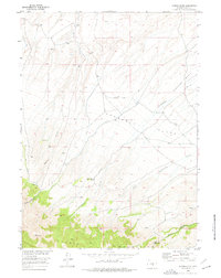
1953 · Spanish Mine
USGS Topo · 1:24,000

1955 · Casper
USGS Topo · 1:250,000

1958 · Casper
USGS Topo · 1:250,000

1961 · Lamont NE
USGS Topo · 1:24,000