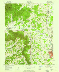
1957 Map of Speed
USGS Topo · Published 1958About this map
Silver Creek and the Muddy Fork dominate the central drainage of this Clark County landscape, where the flatlands of Sellersburg meet the rising terrain of the Knobs. The 1957 revision captures the region's mid-century transportation network, defined by the parallel routes of the Pennsylvania and Monon railroads which served settlements like Memphis and Bennettsville. To the northwest, the heavily wooded Clark State Forest covers the steep ridges, while the southeastern sections show a more developed agricultural and suburban pattern. Local history is preserved through markers such as Atkins Chapel, St Joseph Hill, and several family burial grounds including Hickory Grove Cem and Miller Cem. The map also identifies educational and recreational sites like the Township Sch and Camp Honor Bright, reflecting the community structure of the late 1950s before significant modern expansion.
Find a feature on this map
52 named features on this map. Tap any name to fly to it.
Don’t see what you’re looking for? This feature index may not catch every label — zoom into the map to look around manually.
Map Details
Editions of this 1957 Speed Map
This is the sole edition of this map. No revisions or reprints were ever made.
Other maps of this area

1905 · Prospect
USGS Topo · 1:62,500

1912 · Prospect
USGS Topo · 1:62,500

1937 · Jeffersonville
USGS Topo · 1:24,000

1937 · Charlestown
USGS Topo · 1:24,000

1938 · Speed
USGS Topo · 1:24,000

1939 · New Albany
USGS Topo · 1:24,000

1939 · Georgetown
USGS Topo · 1:24,000

1941 · Borden
USGS Topo · 1:24,000

1946 · Jeffersonville
USGS Topo · 1:24,000

1946 · New Albany
USGS Topo · 1:24,000