1948 Map of Spesutie
USGS Topo · Published 1948About this map
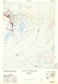
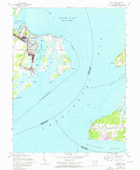
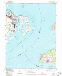
Aberdeen Proving Ground dominates the western shoreline of this 1948 military-to-civilian conversion survey, revealing the specialized infrastructure of the post-war installation. The map documents an auto test course, an abandoned airport, and large gas tanks tucked behind Brier Point. Across the Spesutie Narrows, reached via the Spesutie Island Bridge, Spesutie Island itself is characterized by extensive marshland and scattered observation towers. This area sits at the critical confluence where the Susquehanna National Wildlife Refuge meets the open waters of the Chesapeake Bay. To the east, the rural character of Grove Neck stands in contrast, centered on the small settlement of Grove and the long stretch of Grove Neck Road leading toward the Sassafras River.
Find a feature on this map
40 named features on this map. Tap any name to fly to it.
Don’t see what you’re looking for? This feature index may not catch every label — zoom into the map to look around manually.
Map Details
Editions of this 1948 Spesutie Map
4 editions found

Other maps of this area

1898 · Elkton
USGS Topo · 1:62,500

1898 · Tolchester
USGS Topo · 1:125,000

1899 · Dover
USGS Topo · 1:125,000

1900 · Elkton
USGS Topo · 1:62,500

1900 · Cecilton
USGS Topo · 1:62,500

1900 · Havre De Grace
USGS Topo · 1:62,500

1900 · Betterton
USGS Topo · 1:62,500

1903 · Tolchester
USGS Topo · 1:125,000

1906 · Dover
USGS Topo · 1:125,000

1908 · Tolchester
USGS Topo · 1:125,000