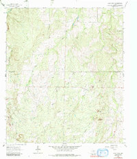
1963 Map of Spice Rock
USGS Topo · Published 1984About this map
The boundary between MC Culloch Co Mason Co divides this ranching landscape where seasonal drainages like Loafer Creek and Tiger Creek carve through the limestone terrain of the Texas Hill Country. The 1963 survey captures the area before modern development, showing a network of fencelines and unimproved roads that connected remote family holdings. Small pockets of industry are visible in the Prospect and scattered Gravel Pits, while natural landmarks like the namesake Spice Rock and Buzzard Roost served as essential navigation points for local inhabitants.
Find a feature on this map
23 named features on this map. Tap any name to fly to it.
Don’t see what you’re looking for? This feature index may not catch every label — zoom into the map to look around manually.
Map Details
Editions of this 1963 Spice Rock Map
2 editions found

Other maps of this area

1887 · Mason
USGS Topo · 1:125,000

1894 · Brady
USGS Topo · 1:125,000

1894 · Mason
USGS Topo · 1:125,000

1954 · Brownwood
USGS Topo · 1:250,000

1954 · Llano
USGS Topo · 1:250,000

1955 · Llano
USGS Topo · 1:250,000

1956 · Llano
USGS Topo · 1:250,000

1962 · Purdy Hill
USGS Topo · 1:24,000
1962 · Fly Gap
USGS Topo · 1:24,000
1962 · Fredonia
USGS Topo · 1:24,000