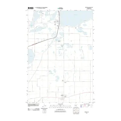
2010 Map of Spicer
USGS Topo · Published 2010About this map
Green Lake and Nest Lake anchor the northern landscape of this region, which is defined by its glacial hydrology and established lakeside communities. The town of Spicer sits at the narrow passage between these two water bodies, serving as a hub for local residents and visitors to the Decision Hills Camp and Green Lake Camp. To the south, the village of Kandiyohi marks the path of the southern rail and road corridor, situated amidst a dense network of smaller basins including Burr Oak Lake and Eagle Lake. Genealogists will find a high density of rural burial grounds, such as the Spicer Family Cemetery, Green Lake Lutheran Cemetery, and Saint Patrick Cemetery, reflecting the long-standing agricultural and community roots in the area. The presence of the Elkhorn Lake Rearing Pond Dam near Elkhorn Lake highlights the local focus on lake management and regional conservation efforts.
Find a feature on this map
56 named features on this map. Tap any name to fly to it.
Don’t see what you’re looking for? This feature index may not catch every label — zoom into the map to look around manually.
Map Details
Editions of this 2010 Spicer Map
This is the sole edition of this map. No revisions or reprints were ever made.
Other maps of this area

1953 · Saint Cloud
USGS Topo · 1:250,000

1956 · Atwater
USGS Topo · 1:62,500

1957 · Saint Cloud
USGS Topo · 1:250,000

1958 · Saint Cloud
USGS Topo · 1:250,000

1958 · Willmar
USGS Topo · 1:24,000

1958 · Solomon Lake
USGS Topo · 1:24,000

1967 · Mount Tom
USGS Topo · 1:24,000

1967 · Hawick
USGS Topo · 1:24,000
1967 · New London
USGS Topo · 1:24,000
1982 · Lake Elizabeth
USGS Topo · 1:24,000