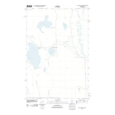
2010 Map of Split Hand Lake
USGS Topo · Published 2010About this map
The Mississippi River meanders through the eastern portion of this Itasca County landscape, defining a complex hydrology of glacial lakes and managed waterways. Central to the map is Split Hand Lake, which, along with Little Split Hand Lake, is regulated by infrastructure such as the Splithand Lake Dam and Little Splithand Lake Dam. This network of water is further connected by the winding Split Hand Creek, which flows eastward toward the river. To the north, the landscape is dotted by Cow Horn Lake and Little Cow Horn Lake, while the southern reaches extend into the Savanna State Frst. Human activity is marked by a grid of rural routes like Splithand Rd and River Rd, as well as the small Porter Airport in the southeast, reflecting a region where natural resources and recreational geography predominate.
Find a feature on this map
25 named features on this map. Tap any name to fly to it.
Don’t see what you’re looking for? This feature index may not catch every label — zoom into the map to look around manually.
Map Details
Editions of this 2010 Split Hand Lake Map
This is the sole edition of this map. No revisions or reprints were ever made.
Other maps of this area

1953 · Grand Rapids
USGS Topo · 1:24,000

1953 · Duluth
USGS Topo · 1:250,000

1954 · Hibbing
USGS Topo · 1:250,000

1957 · Hibbing
USGS Topo · 1:250,000

1958 · Hibbing
USGS Topo · 1:250,000

1958 · Duluth
USGS Topo · 1:250,000

1964 · Hibbing
USGS Topo · 1:250,000

1969 · La Prairie
USGS Topo · 1:24,000
1970 · Warba
USGS Topo · 1:24,000

1970 · Split Hand Lake
USGS Topo · 1:24,000