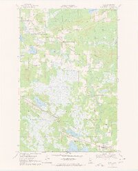
1970 Map of Warba
USGS Topo · Published 1972About this map
Warba and the surrounding townships of Blackberry and Feeley are defined by a complex network of wetlands and glacial lakes in this 1970 survey. The Burlington Northern railroad cuts a straight diagonal across the marshy lowlands near the small settlement of Philbin, paralleling a major pipeline corridor. This transport-heavy corridor contrasts with the irregular meanders of the Swan River, which flows through the eastern half of the quadrangle. Local genealogy and community life are anchored by the Trout Lake Cem and Trout Lake Ch in the north, and the Feeley Cem located just outside Warba. Small-scale aviation is represented by private facilities like the Flying K Ranch Landing Strip, while several Gravel Pits indicate the local extraction industry during the early 1970s.
Find a feature on this map
35 named features on this map. Tap any name to fly to it.
Don’t see what you’re looking for? This feature index may not catch every label — zoom into the map to look around manually.
Map Details
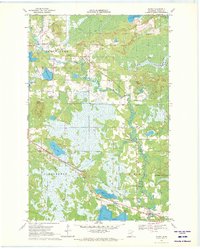
Editions of this 1970 Warba Map
2 editions found
Other maps of this area

1920 · Trout Lake
USGS Topo · 1:62,500

1952 · Calumet
USGS Topo · 1:24,000

1952 · Pengilly
USGS Topo · 1:24,000

1952 · Bovey
USGS Topo · 1:24,000

1954 · Hibbing
USGS Topo · 1:250,000

1957 · Hibbing
USGS Topo · 1:250,000

1958 · Hibbing
USGS Topo · 1:250,000

1964 · Hibbing
USGS Topo · 1:250,000

1969 · La Prairie
USGS Topo · 1:24,000
1969 · Goodland
USGS Topo · 1:24,000