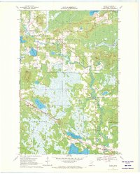
1970 Map of Warba
USGS Topo · Published 1972About this map
Warba serves as the primary hub for this Itasca County landscape, situated near the intersection of the Burlington Northern railroad and the Swan River. The terrain is characterized by a dense network of glacial wetlands and water bodies, including Rice Lake, Sand Lake, and Shallow Lake, which dominate the southern half of the quadrangle. Transport and infrastructure are central themes of the era, marked by prominent pipelines cutting across the Blackberry and Feeley townships and a pair of private airfields: Flying K Ranch Landing Strip and Buds Ranch Landing Strip. Local history is anchored by the Townhall and Trout Lake Ch in the north, while the Feeley Cem and Trout Lake Cem provide valuable records for genealogical research. The map captures a moment when the rail-and-river economy still shaped the small settlements of Philbin and Swan.
Find a feature on this map
34 named features on this map. Tap any name to fly to it.
Don’t see what you’re looking for? This feature index may not catch every label — zoom into the map to look around manually.
Map Details
Editions of this 1970 Warba Map
2 editions found
Other maps of this area

1920 · Trout Lake
USGS Topo · 1:62,500

1952 · Calumet
USGS Topo · 1:24,000

1952 · Pengilly
USGS Topo · 1:24,000

1952 · Bovey
USGS Topo · 1:24,000

1954 · Hibbing
USGS Topo · 1:250,000

1957 · Hibbing
USGS Topo · 1:250,000

1958 · Hibbing
USGS Topo · 1:250,000

1964 · Hibbing
USGS Topo · 1:250,000

1969 · La Prairie
USGS Topo · 1:24,000
1969 · Goodland
USGS Topo · 1:24,000