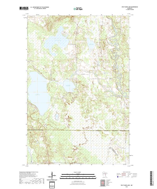
2022 Map of Split Hand Lake
USGS Topo · Published 2022About this map
Split Hand Lake and its smaller counterpart, Little Split Hand Lake, anchor this northern landscape where the Mississippi River winds through the eastern edge of the quadrangle. The map captures a transition point at the Itasca Co Aitkin Co line, showing a region defined by its complex hydrology. Named water bodies like Cow Horn Lake and Mud Lake are connected by a network of drainage features including Split Hand Cr. Human activity is concentrated along established corridors like Co Hwy 3 and Splithand Rd, while the presence of Porter Airport and the UPM/Blandin Trl suggests a modern land use pattern that balances recreational trails with local infrastructure. The many wetland boundaries surrounding the lakes emphasize the watery character of this Upper Mississippi basin territory.
Find a feature on this map
36 named features on this map. Tap any name to fly to it.
Don’t see what you’re looking for? This feature index may not catch every label — zoom into the map to look around manually.
Map Details
Editions of this 2022 Split Hand Lake Map
This is the sole edition of this map. No revisions or reprints were ever made.
Other maps of this area

1953 · Grand Rapids
USGS Topo · 1:24,000

1953 · Duluth
USGS Topo · 1:250,000

1954 · Hibbing
USGS Topo · 1:250,000

1957 · Hibbing
USGS Topo · 1:250,000

1958 · Hibbing
USGS Topo · 1:250,000

1958 · Duluth
USGS Topo · 1:250,000

1964 · Hibbing
USGS Topo · 1:250,000

1969 · La Prairie
USGS Topo · 1:24,000
1970 · Warba
USGS Topo · 1:24,000

1970 · Split Hand Lake
USGS Topo · 1:24,000