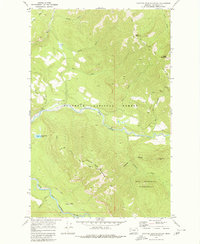
1970 Map of Spotted Bear Mountain
USGS Topo · Published 1980About this map
Flathead National Forest and the Bob Marshall Wilderness dominate this 1970 landscape, centered on the high vantage of Spotted Bear Lookout. The terrain is defined by a dense network of pack and foot trails that traverse the ridges between the Spotted Bear River and the South Fork Flathead River. This area serves as a primary backcountry corridor, where the Spotted Bear Mountain Trail (Pack) and Schafer Trail provide access to interior summits like Spotted Bear Mountain and Bent Mountain. The map illustrates a high-altitude drainage system where numerous creeks, such as Nanny Creek and Jungle Creek, feed into the larger river valleys. Unlike maps of more settled regions, this survey documents a purely wilderness-oriented infrastructure of lookouts and pack routes used for forest management and remote exploration before the modern era of high-frequency satellite monitoring.
Find a feature on this map
27 named features on this map. Tap any name to fly to it.
Don’t see what you’re looking for? This feature index may not catch every label — zoom into the map to look around manually.
Map Details
Editions of this 1970 Spotted Bear Mountain Map
Other maps of this area

1913 · Marias Pass
USGS Topo · 1:125,000

1914 · Nyack
USGS Topo · 1:125,000

1936 · Silvertip
USGS Topo · 1:96,000

1942 · Silvertip
USGS Topo · 1:125,000

1955 · Choteau
USGS Topo · 1:250,000

1957 · Choteau
USGS Topo · 1:250,000

1958 · Choteau
USGS Topo · 1:250,000

1958 · Capitol Mountain
USGS Topo · 1:24,000

1958 · Circus Peak
USGS Topo · 1:24,000

1958 · Horseshoe Peak
USGS Topo · 1:24,000